Introduction
At Macleod Simmonds, we pride ourselves on pushing the boundaries of innovation and precision in Highway, Structural, Geophysical, Utility and Land Surveying. Recently, we were tasked with a critical project to help shape the City of London's new planning strategy by assessing utility congestion beneath its main carriageways.
The Client
The City of London, also known as the Square Mile, is the financial district of London. One of the reasons the Square Mile is unique, is the number of people who live, work and visit. In just 1.12 square miles, the City of London counts 8,600 residents, 678,000 workers and millions of domestic and international visitors. The City of London boundaries stretch from Temple to the Tower of London, on the River Thames including, from west to east Chancery Lane and Liverpool Street.
The Challenge
As urban development in the City accelerates, the demand for access to core utility services has skyrocketed. This surge in construction activities has made it increasingly challenging to lay new services within the already congested carriageways. To address this, Macleod Simmonds was asked to develop a scientifically based methodology for a large-scale assessment of the congestion present beneath the City's road network.
Our solution
Leveraging our extensive experience in surveying buried utilities and structures, we devised an innovative approach to map out congestion levels beneath the City's highways. Our main objective was to deliver a clear, easy-to-understand, colour-coded overview of congestion levels: Green: Less than 49% congestion; Yellow: 50% - 69% congestion; Orange: 70% - 89% congestion; Red: Above 90% congestion.
“We needed a scientific approach to assessing the levels of congestion beneath our streets to support our future planning strategy.”
Giles Radcliffe, Assistant Director, City of London
Methodology
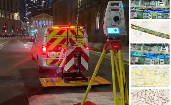
Our team utilised the advanced Kontur GS-MK4N Step Frequency Ground Penetrating Radar (GPR) system, coupled with the DXG2124 antenna system, to scan 25km of carriageways in live traffic. With years of experience in capturing towed GPR array data around the RTK shielded concrete canyons of the City, we developed an efficient strategy for data collection. This, combined with a unique application of existing algorithms within Kontur’s Examiner software suite, allowed us to create the necessary visualisations swiftly.
Impact
The resulting assessment map offers a reliable visualisation of the volume of free space between the surface, up to a depth of 1 metre, available within the City's carriageways. This map is now a valuable tool in planning negotiations, used regularly to inform decisions and ensure the seamless execution of future construction developments.
“Having a ready-to-use solution has been hugely helpful, negating the need to complete a new survey for every single project.”
Giles Radcliffe, Assistant Director, City of London
Summary
Macleod Simmonds' expertise and cutting-edge technology enable us to contribute meaningfully to the City's development while ensuring that utility services are efficiently integrated within its dynamic landscape. By leveraging advanced GPR technology, we delivered a clear and actionable assessment map which can be used to inform future construction development decisions without having to undertake a new survey every time.