Elevating Geospatial Mapping with Cutting-Edge IDS Stream DP Array Systems
15 April 2025 by: Craig Simmonds
Macleod Simmonds, the multi-award-winning geospatial mapping experts, are thrilled to announce the acquisition of two new IDS Stream DP Array systems. This strategic investment underscores our unwavering commitment to leveraging industry-leading technology to deliver unparalleled accuracy and reliability in geospatial mapping.
The IDS Stream DP Array systems represent the pinnacle of ground-penetrating radar (GPR) technology
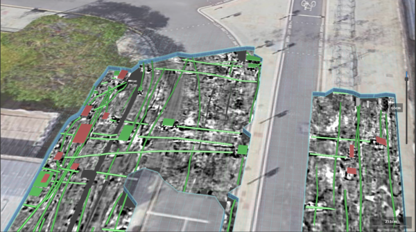
The IDS Stream DP offers superior depth penetration and real-time 3D mapping capabilities. These advanced systems are designed to detect and map underground utilities and features with unprecedented precision, ensuring that Macleod Simmonds continues to set the standard in the industry.
The IDS Stream DP features new cutting-edge Equalised scrambled technology (EST) which takes underground asset detection to an even deeper level. By integrating the IDS Stream DP Array systems into our existing array fleet operations, we can provide our clients with the most detailed and accurate geospatial data. Combined with Macleod Simmonds’ innovative methodologies, we have the ability and expertise to tackle even the most challenging mapping projects.
The benefits of the IDS Stream DP:
- GPR signal capable of extended depth range and ultra-high resolution.
- Ability to create a highly accurate and detailed 3D reconstruction of the underground utility network in a single scan.
- Greater efficiency making it quicker and more cost-effective for our clients.
- Works on both rugged and asphalt terrains.
The advanced depth capability of the IDS Stream DP delivers a resolution you simply would not achieve with lower spec equipment. Typically, to go deeper requires a lower frequency antenna, which compromises the resolution. Whilst deeper scanning will not necessarily detect more utilities, it does produce clearer and more data – giving you more confidence in the accuracy and reliability of the results.
This investment in the IDS Stream DP Array systems is part of our ongoing pursuit of excellence and determination to provide our clients with the highest quality geospatial mapping services.
What type of surveys can the IDS Stream DP perform:
The IDS Stream DP mainly performs geophysical and PAS128 utility surveys, looking for anomalies, voids, buried structures and utilities.
For more information about the IDS Stream DP and our other cutting-edge geospatial mapping solutions please get in touch:
Book a Demo